
Case studies using our survey software
We help people in the field do their job faster and easier. With real-life experience at the heart of our software, we help professionals do today what they couldn’t do yesterday. See how.
All
Surveying & Mapping
3D Documentation
Construction
GCP
Workflow
Features
Architecture
Mining
CAD
Inspection & Public Safety

Creating a custom plane orthophoto of a round tower
For this project, Mate Denona, needed to create an orthophoto of the inner and outer walls of a round tower. Read his challenging process.
Advanced Point Cloud Cleaning and Classification
Discover how the Select by Color feature in 3Dsurvey photogrammetry software revolutionizes point cloud editing and classification.
Surveying with dense vegetation, drone crash and Videogrammetry
Explore how we dealt with dense vegetation and a drone crash at Soteska castle.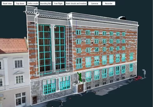
Custom Plane Orthophoto and Extracting Window Dimensions
Discover how easy it is to extract window dimensions with a custom plane orthophoto using the integrated 3Dsurvey CAD module.
Autel EVO II Pro 6k RTK vs DJI Phantom 4 RTK Drone
Comparison of two of the most popular drones in the market. Discover the similarities and differences and our recommendations.
Solar Power Installation Planning using Photogrammetry
The aim of this showcase was to produce an accurate solar power panel layout for installation on a rooftop using photogrammetry software.
Using photogrammetry for 3D documentation of cultural heritage
Read about how photogrammetry can be used for 3D documentation of cultural heritage sites, such as this 12th century monastery.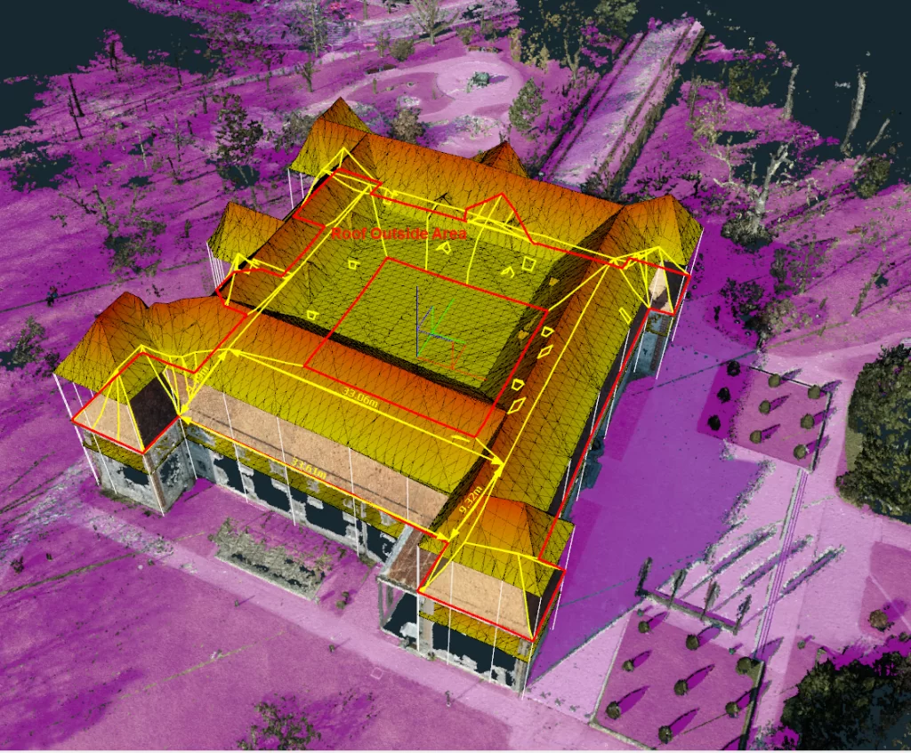
Preserving Architectural heritage with 3Dsurvey – Castle of Sobota
Learn how 3Dsurvey software and drone photogrammetry can be used to calculate 3D area and help with preserving architectural heritage. 
3Dsurvey mission: mobile photogrammetry development
Find out about 3Dsurvey's mission to develop their own mobile photogrammetry solution by mounting a drone to a car. 
Surveying and evaluating a shooting range using photogrammetry
Surveying and evaluating a shooting range in South Africa using drone imagery and 3Dsurvey photogrammetry software. 
3D Documentation of Church Tower for Reconstruction in Slovakia
Making a 3D model of a church tower for the purpose of measuring the surface of the cladding so it could be reconstructed later. 
Creating virtual reality with photogrammetry and 3Dpro
This project aimed to create an interactive 3D model of a high school building for students to virtually explore and walk through. 
Extract building corners easily with X-ray orthophoto
X-ray automatically creates an orthophoto map of the walls by recognizing groups of vertical points and identifying them as the walls.
Drone Mapping in the City of Sedona, AZ
Read about Farrah Etcheverry's drone mapping project in Sedona, where she completed a Topographic survey and Boundary survey.
Cadastral measurement of buildings – the easy way
Read about accurate spatial data acquisition for cadastral boundaries using a drone and photogrammetry software. 
Family house water drainage study in Tuscon, AZ
Surveyors Source LLC was contacted to conduct a survey of a property in Tuscon to determine water drainage.
Archaeology and 3D documentation – St. Hubert 3D model
3D documentation of a zinc statue of St Hubert and a deer using only a standard digital camera, an Olympus EP2, and photogrammetry software. 
Photogrammetry as a Tool for Forensic Documentation
Police departments can use photogrammetry with integrated CAD for easier and more accurate forensic documentation and analysis. 
Oil tank construction monitoring in Denmark
Construction monitoring of an oil terminal in Denmark using drone imagery, ground control points and total station.
Site monitoring with a UAV and 3Dsurvey
Using a UAV and photogrammetry software for site monitoring of the demolition of a large power station in Germany. 
Facade mapping of the Ljubljana Central Market building
Effective facade mapping of the Ljubljana Central Market building with a standard digital Olympus EP2 camera and photogrammetry software.
3D Documenting a 1894 garden shed for cultural preservation
Creating a 3D model of an old garden shed using photogrammetry for the purpose of renovation and preserving cultural heritage.
Renovation planning using phone images and laser scanner
Renovation of Ljubljana Castle's wine cellar patio with data from a Google smartphone and terrestrial laser scanner.
Drone-based surveying for determining a sewage system in a town
Using drone-based surveying to map and measure terrain for the purpose of constructing a sewage system in a small town. 
Combining photogrammetry and bathymetry in a single software
Using both photogrammetry and bathymetry to calculate the volume of material that was dug out of a lake.
Indoor Mapping of a House with a Phone Camera
Geo-referenced indoor 3D mapping of a two storey building using a smartphone Google Pixel I and ground control points. 
Stockpile measurement with Fixed-wing UAS
Using the C-Astral Fixed-wing Bramor ppX UAS with Sony Alpha 6000 camera for stockpile measurement of a site in Arizona. 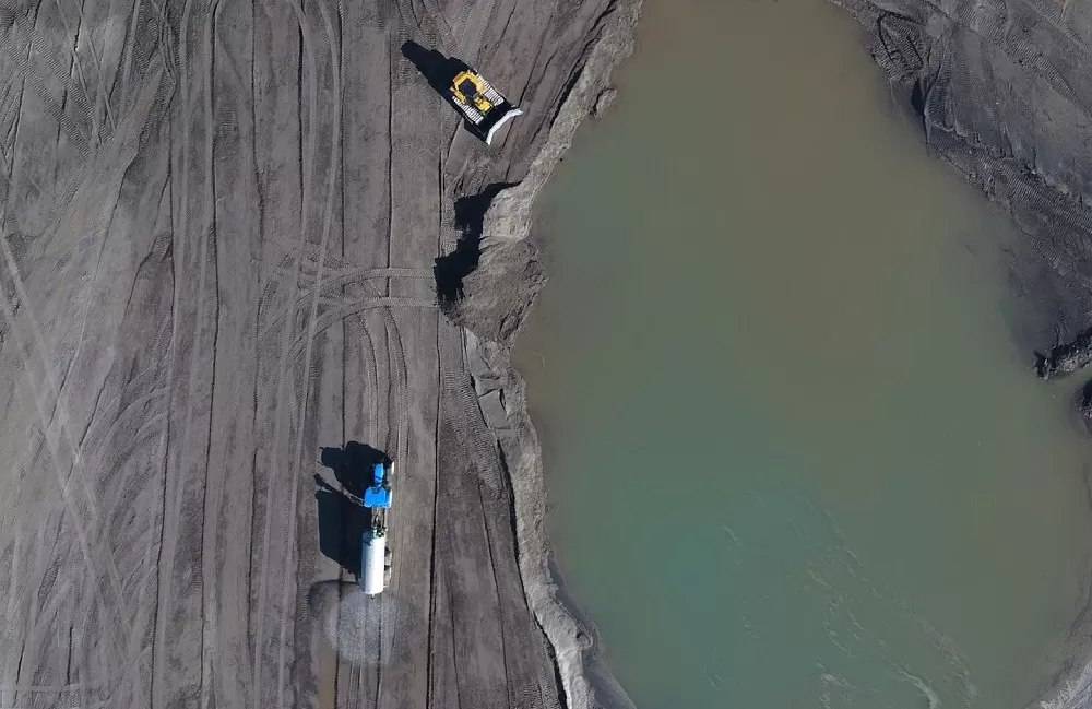
Drone Mapping and Volume Calculation for Subsidence Repair
Mining company, PV Invest d.o.o. based in Velenje, Slovenia, used a drone-generated 3D Model for volume calculation of surface subsidence.
Mapping and Modelling Cadastral Boundaries using Drones
Mapping and modelling cadastral boundaries using a Phantom 4 drone, GCPs, independent validation points and 3Dsurvey photogrammetry software.
Consumer drone data for professional land surveying
Can a consumer drone deliver data needed for professional land surveying results? We tested a DJI Phantom 4 on a small sized landfill.
3D mapping for House renovation
Drone 3D mapping and photogrammetric processing to design and plan facade and roofing upgrades for a home renovation in Croatia.
Drone Topographic Survey of a Landfill near Dubrovnik, Croatia
Topographic survey of a landfill near Dubrovnik using a Sky Hero 8 rotary drone and Olympus EPL7 camera, along with 3Dsurvey software.
River embankment mapping for a Hydropower Plant in Boštanj
Mapping a section of a river embankment near a hydropower plant in Boštanj, Slovenia using a DJI S900 drone.
Survey plan for a Family house project in Tišina
Survey plan for a Family house project in Tišina using a DJI S900 drone at 80m altitude with an Olympus EPL7 camera.
Potoška planina landslide measurements
Comparing terrestrial and photogrammetry measurements of the Potoška planina landslide in October 2015 with a rotary drone and iron poles.
Orthophoto map 1 mm resolution – City centre square renovation
Our first cultural heritage project done using photogrammetry to create a hi res orthophoto map with 1mm resolution. 
Potoška Planina Scree Accumulation from 2014 to 2015
The goal of this project was to observe the scree that had accumulated on the Potoška mountain slopes using data from 2014 and 2015. 
Measuring 1.6km of the Rakek railway line
The main objective of this project was to observe, measure and 3D map 1.6km of railway line in Rakek and the station infrastructure. 
Potoška Planina Landslide – Volume Calculations
Volume calculations of the Potoška Planina slopes over a 3 year period to note the total land mass movement and define displacement vectors.
Slano Blato Landslide – Drone Observation
10 drone flights at 80m altitude were needed to monitor the changes in the land mass movement on the southern edge of the Trnovo Plateau. 
Survey Mapping an Open-pit Mine
Survey mapping an open-pit mine in Litija, Slovenia and generating an accurate 3D model and an orthophoto map. 
Construction site excavation and volume calculation
This project involved 2 separate measurements and volume calculation of a large-scale construction site in Ljubljana city centre.
River bank measurements over a 6 month period
River bank measurements over a 6 month period in 2014 in cooperation with the Faculty of Civil and Geodetic Engineering, Ljubljana University.
Survey Map and Boundary Survey of a Golf Course
Using a drone to create a survey map and perform a boundary survey of a golf course offers several advantages. 
Bridge Renovation Planning – Orthophoto map and 3D model
Bridge renovation planning using aerial photographs, a calculated point cloud and an orthophoto map. 
700m Road Visualisation with Proposed Changes
A 700m road measurement and visualisation project to see a realistic 3D model of the proposed changes to the planned road. 
Geodetic plans for railway and road
Unmanned aircraft vehicles/drones are ideal data gathering tools for creating geodetic plans for longitudinal works such as roads or railways.
Using photogrammetry for planning bridge renovations
Using photogrammetry technology to examine all cracks, faults and potential dangers that need to be considered when renovating a bridge.
Surveying a 45m tall pillar of a highway bridge using a UAV
Using an unmanned aerial vehicle, we surveyed a 45m highway pillar in the vicinity of Žiče in eastern Slovenia.
Podpeč and Bezovica mountain cliff measurement
Using the UAV Microdrone MD4-1000, we surveyed mountain cliffs to determine the rocks that posed a danger to the nearby villages.
Volume calculations – Brdo
Using aerial photography and GCPs we measured the volume of excavated material and material fill, enabling better construction management. 
Orthophoto Maps and Cadastre for Cemeteries
An exact orthophoto map presents a basis for GIS database production. The resolution of the cemetery orthophoto map is 2 centimetres. 
Land surveying a wastewater treatment plant
Land surveying a wastewater treatment plant and calculating material volume based on contrasting several consecutive measurements. 
Quarry volume calculations and excavated material monitoring
The quarry of several hectares was measured in two 25-minute drone flights. The data was then processed using 3Dsurvey.